SCOR brings its technical expertise to the development of a new pasture insurance scheme in Canada
November 30, 2017
According to FAO (the Food and Agriculture Organization of the United Nations), pasture represents more than 25% of the earth’s land area. This pasture constitutes the main source of production for various food industries (meat, milk, cheese, etc.). Despite the fact that it is highly exposed to climatic events, only a tiny part of this land is insured.
According to FAO (the Food and Agriculture Organization of the United Nations), pasture represents more than 25% of the earth’s land area. This pasture constitutes the main source of production for various food industries (meat, milk, cheese, etc.). Despite the fact that it is highly exposed to climatic events, only a tiny part of this land is insured.
SCOR, loyal to its long-term commitment to the sustainable development of insurance, is involved in a large project to develop a new pasture insurance scheme in Canada.
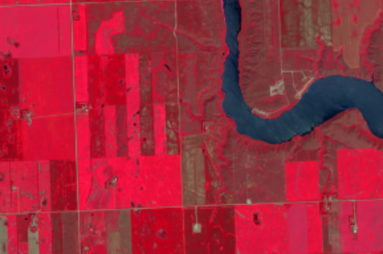
The cutting-edge satellite processing technology developed by Airbus Defence and Space has already been used in France to implement a successful pasture insurance scheme. On the initiative of SCOR, which is closely involved with this scheme in France, the same techniques are now being tested in Canada.
This multiyear project is led by the Saskatchewan Cattlemen’s Association (SCA) and Alberta Beef Producers (ABP), and involves an interdisciplinary research team composed of members from SCOR, the University of Manitoba, the University of Waterloo, Nanyang Technological University (Singapore) and Airbus Defence and Space (France), working with the Saskatchewan Crop Insurance Corporation (SCIC) and the Agriculture Financial Services Corporation (AFSC).
Working in both the Saskatchewan and Alberta provinces, historical ground data have been collected and carefully analyzed. Independently, 15 years’ worth of satellite imagery has been processed to extract the exact behavior of the grassland in each cell (aggregations of pixels), through several indices. During this first phase of the project, satellite measurements have been analyzed and compared with collected ground data.
The project is funded by the Canadian Federal Government, the SCOR Foundation and the Society of Actuaries.
Federal funding is granted through the AgriRisk program, which supports research and development as well as the implementation and administration of new risk management tools for use in the agriculture sector. AgriRisk is a Growing Forward 2 Business Risk Management initiative.
SCOR’s agriculture team, combining remote sensing, agronomy and actuarial experience, brings its technical expertise to the scheme. With this project, SCOR once again demonstrates its ability to federate the best network of technical partners, and to bring value and know-how to the insurance industry through long-term projects.

© Airbus DS 2014
* * *
For more information on this project, please refer to the press release issued by the Government of Canada: https://www.canada.ca/en/agriculture-agri-food/news/2017/11/satellite_technologyhelpsranchersmanagefeedcrops.html
To know more, technical newsletters are available (Part I - Overview of new satellite offering and use & Part II - Satellite imagery technology)
Read the PDF